
Phantom borders are borders that no longer officially exist but which can still be seen on various maps. Not because countries are still claiming them but because the former borders influenced some other phenomenon which hasn’t changed now that the border is gone. For example the election maps of Poland still show the former borders of the German empire as they existed until the first world war. Maps of Berlin also still show the division of the city during the Cold War because the east and west used different types of street lamps. The same division is also visible in the tram map (the communists kept the trams whereas West Berlin demolished them in favour of busses).


These phantom borders may not be as clearly visible every year depending on the circumstances. The old imperial borders of the German Empire and the Austro-Hungarian Empire in Poland and Romania respectively can be hidden slightly in elections if one party does unusually badly.

Another phantom border that influences life today is the border along the former Iron Curtain dividing Germany into East and West Germany during the Cold War. It is clearly visible in the German election results with both the formerly communist Die Linke and the far-right AfD winning big in the east:

The phantom borders in Poland, Romania, Germany and as we’ll see later also in Italy are caused by countries having different policies and as a result different degrees of economic success. These economic disparities can persist far longer than the borders do, primarily because the infrastructure lives on. This can even persist when the population of a region is completely replaced. The western half of Poland used to be primarily populated by Germans until the end of the second world war. At the end of the war the Red Army drove the Germans out of their historic homelands and awarded it to the Poles (which then allowed them to steal historically Polish lands and settle those with Belarusians, Ukrainians and Russians). So even though poor Polish peasants from the far east of Poland were moved into the now formerly German cities in the west we still see these people voting for the liberal, progressive and upper middle class political party today. Their cultural norms have adapted based on the existing infrastructure defined by the phantom border. An excellent natural experiment to support cultural Evolutionary Modernization Theory.
Influence of policy on material wealth
In case you are sceptical whether a country’s policies can really influence material wealth just have a look at the Haïti-Dominican Republic border and the border between North and South Korea. The Haïtian side of the border is heavily deforested due to mismanagement and overexploitation by its poor inhabitants whereas just across the border plenty of trees remain. The same goes for communist North Korea which basically has no lights on at night compared to South Korea and China:


Old borders do fade
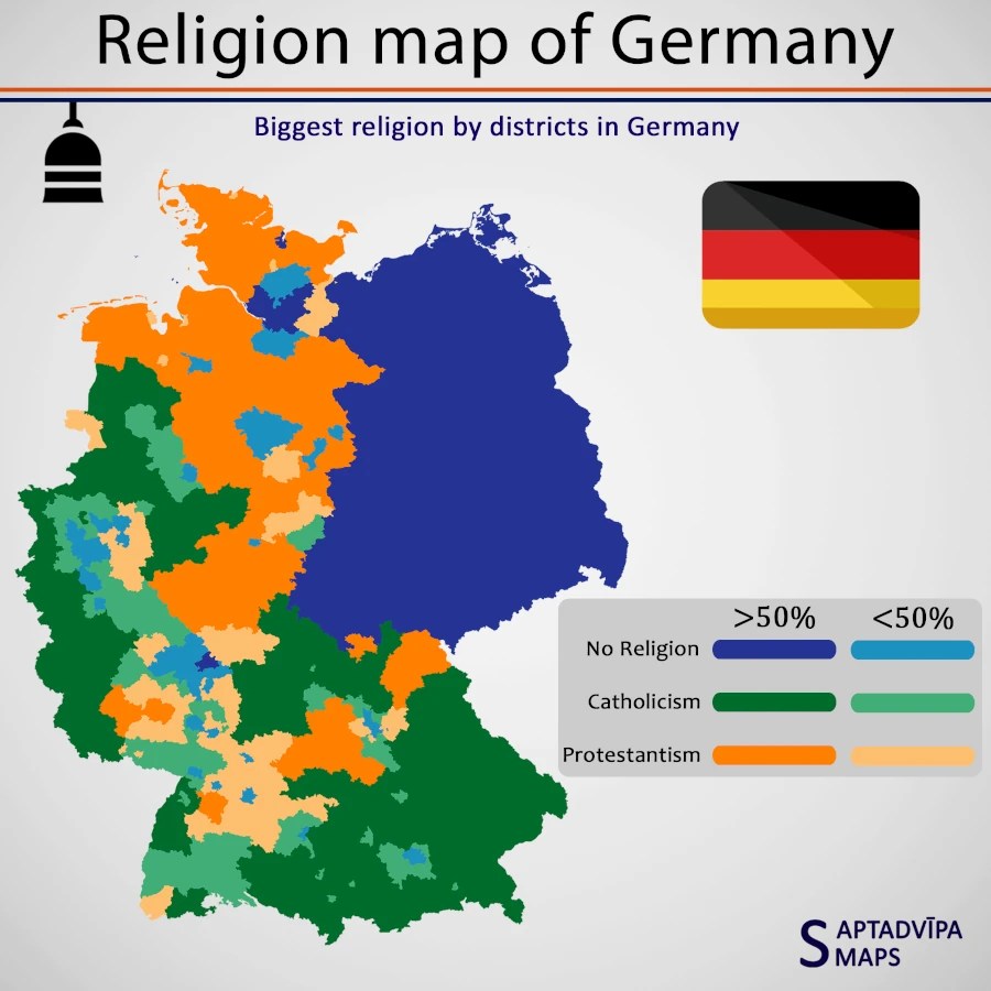
In East Germany the communists also successfully tried to stamp out religion as they saw it as a threat to communism and a cynical means to oppress the population. The map below still clearly shows the former border. However this phantom border in the religious distribution may not be visible by the end of this century anymore because the western half of the country is rapidly becoming atheist as can be seen in the major cities (also note that this map is from the 2011 census and if made today would be considerably bluer already).
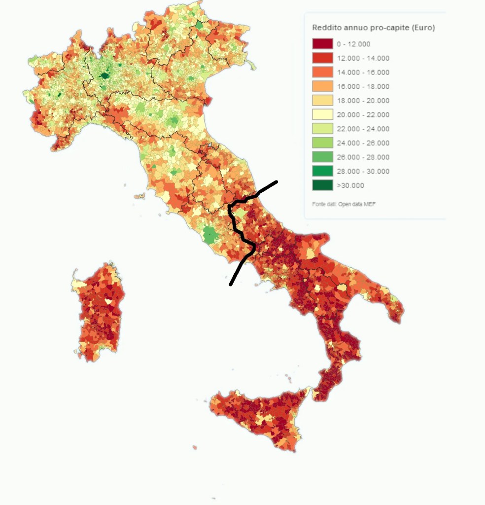
On the map below I’ve drawn the northern border of the Kingdom of the Two Sicilies on top of a map of the income per capita for Italy per municipality. We can clearly see that the former territory of the Kingdom of the Two Sicilies is considerably poorer than the north a difference that has been around for centuries. This southern region was governed by large centralised states from 1282 to 1861, unlike the north which consisted a patch work of small city states that fervently competed against each other. And while the maffia have spread out across Italy and the world in the last century or so, it is also this southern region where all the major maffia organisations originate. Unlike the very sharp phantom borders at the start of this article, the one in Italy is rather fuzzy because in the 160 years that Italy has been unified the socioeconomic differences have slightly equalised.
Borders between land and sea
The coolest example I’ve seen of a phantom border though isn’t so much a former political border but a former physical border. I’m talking about the former coastline of the Western Interior Seaway that existed 100 Mya. As you can see in the maps below, the coastline influenced to soil types, which then proved to be good for establishing slave plantations which can still be seen in the election results today.


Leave a Reply